


AeroSync is a modular drone monitoring system designed to track wild elephant movements when they enter populated areas.

The Migration of the Short-Nose Family
The In 2020, a group of wild Asian elephants known as the "Short-Nose Family" left their home in Xishuangbanna, Yunnan, and began migrating north, becoming a global sensation. They traveled through villages and cities inhabited by humans, reaching the northernmost point ever recorded for Asian elephants in China, challenging the limits of their survival.

Major causes of wild elephant migration
The major reason for their migration lies in the shrinking natural habitat and the growing population, which has compelled them to venture out in search of food.


Terrain study of Yunnan
Yunnan boasts a remarkable forest coverage rate of 65.04%. The southern region of Yunnan, specifically Xishuangbanna, is home to unique tropical ravine rainforests. These ravine rainforests serve as the native habitat for the short-nosed elephant population.
However, the complex and dense terrain of the rainforest poses significant challenges for tracking wild elephant herds. The thick vegetation, steep ravines, and fragmented forest areas make it difficult to monitor their movements accurately.
Human interaction with wild elephants


Executive Summary

Goals of project
After analyzing the migration patterns of the Short-nosed Family, I realized the significant expenditure of time, money, and resources involved. Despite these efforts, experts suggest that elephant migrations will continue. Therefore, the goal of this project is to design an efficient system that maximizes effectiveness while minimizing resource input.

Painpoints

1, Lost of tracking
Dense forests, mountains, or rivers can interrupt tracking signals, leading to potential loss of contact with the elephants.
2, Separate movements
Elephants have complex social structures and may split or regroup unpredictably, making it challenging to keep track of all individuals.
3, Battery constraints
Drones typically have limited flight time, which significantly restricts the coverage area and duration of each tracking session.

Stakeholder map
1, Monitoring Teams/ forest fire department
Responsible for deploying the system, managing real-time tracking, and ensuring both human and elephant safety.
2, Villagers and Passing Vehicles
People living or traveling through areas affected by elephant migration need to be informed promptly to avoid conflict or accidents.
3, Elephants
(Indirect Stakeholder)
Their natural behaviors and movements need to be monitored carefully to minimize human-elephant conflicts.
Ideation Development

The ideation process focused on exploring modularity — finding a form language that allows individual units to connect seamlessly while maintaining aesthetic harmony and functional integrity.
Through iterative sketching, I aimed to balance form, usability, and system logic, ensuring that the design not only looks cohesive as a whole but also performs effectively as a single unit.
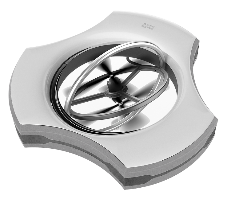
Technical Features
Technical gimbal
The drone is equipped with a technical gimbal, enabling it to change direction and navigate across various angles, making it highly adaptable to the challenging forest terrain in Yunnan.
Electromagnetic Connection
Additionally, an electromagnetic mechanism is integrated beneath the metal strip on the side, allowing individual modules to seamlessly connect and disconnect during flight.


Modular Drones System
Modular drones system are autonomous, individual drone units designed to link together, forming a larger, coordinated structure. Each module typically has its own propulsion system and sensors, allowing it to function independently or as part of a larger array.


Infrared Cameras & ai machine learning
Detect heat signatures with AI algorithms trained on elephant thermal patterns, enabling accurate elephant monitoring even in challenging visibility conditions.

Laser Positioning
uses lasers to determine the exact position of elephants by measuring the distance between the laser source and the target.
Component assembly & prototype iteration
For the final working prototype, I went through several iterations of the frame, focusing on creating a robust structure to protect the internal components. Key considerations during the design development included precise measurements, structural integrity, and alignment with the desired aesthetic. After flight testing, the prototype demonstrated both visual appeal and structural durability.

Exploded View of Shell and Internal Components
Here is the exploded view showcasing both the shell and internal components. The shell is presented as a rendering to illustrate the design concept, while the prototype incorporates all the gathered components, connected to ensure full functionality. Additionally, the gimbal on the prototype has been iterated and integrated with a servo motor to ensure smooth movement during test flights.

Infrared camera &
AI machine learning coding

The code processes data from an infrared camera by reading temperature values through a UART connection. After validating the incoming data frame, it converts the raw temperature readings into a visual format.
For each pixel in the sensor's field of view, it maps the temperature to a brightness value between 0-255, where hotter areas appear brighter and cooler areas appear darker. The code then transforms this grayscale image into a rainbow-colored thermal visualization that can be displayed on an LCD screen, making temperature differences easily visible to the human eye.
Step 1: Image gathering
Step 2: Data Preparation & Training
marked Thermal images of elephants were uploaded to MaxiHub platform, Dataset was split into a 9:1 ratio of training set & testing set.
Step 3: Model Training Progress
The loss graph demonstrates the learning curve over 90 epochs. Both curves converge near zero, suggesting successful model training
step 4: Detection Result
The trained model successfully identifies elephants in thermal images. Each detection is marked with a bounding box and confidence score from 0 to 1.
Real-time monitoring Interface
Equipped with infrared cameras enhanced by AI-powered machine learning capabilities, drones can accurately identify wild elephants as they approach human activity boundaries. This modular drone system enables the monitoring team or forest management personnel to track the elephants in real-time. Simultaneously, they can send alerts to nearby residents through multiple communication channels, including mobile notifications, public broadcasts, and other alert systems, ensuring timely warnings to mitigate potential conflicts and enhance safety.

Map interface
Infrared interface
Alert interface
Evacuation interface


Autonomous Monitoring
When a wild elephant is detected, monitoring drones are deployed to track its movements in real time, ensuring precise surveillance.
Infrared Tracking
Equipped with infrared camera, the drone enables the monitoring team to locate and track elephants even in dark conditions or challenging terrains.
Alert System
Activation Upon detecting an elephant entering a human activity area, the operator can immediately dispatch alerts through an integrated communication system to warn nearby residents and mitigate potential risks.


Systematic workflow
The process begins with the detection of wild elephants through surveillance networks, followed by immediate deployment of monitoring teams. Drones are then launched to track elephant movements and gather real-time data. The system issues alerts to local residents through various communication channels, and finally implements non-invasive intervention methods to safely guide elephants back to their natural habitat.

Drone kit inside
The drone kit is specially designed for forest firefighting team in Yunnan who have dual responsibilities of elephant monitoring and public safety. All components are housed in a rugged protective case that's integrated into fire trucks for rapid deployment. This setup enables firefighters to efficiently monitor elephant movements, coordinate public evacuations, and maintain continuous surveillance by rotating drones and batteries as needed.

